Foremost Clean Energy Successfully Completes 2,695 m Drill Program at its Murphy Lake South Uranium Property
VANCOUVER, British Columbia, Nov. 17, 2025 (GLOBE NEWSWIRE) -- Foremost Clean Energy Ltd. (NASDAQ: FMST) (CSE: FAT) ("Foremost" or the "Company"), is pleased to announce the successful completion of its seven-hole, 2,695 metres diamond drill program at the Murphy Lake South Uranium Property (“Murphy”), located in the Athabasca Basin, northern Saskatchewan (figure 1). This was the first drill program at Murphy since 2017, which was designed to follow up on high-priority targets originally advanced by Denison Mines Corp. (“Denison”, TSX: DML; NYSE American: DNN). Leveraging Denison’s extensive historic drilling and geophysical data, Foremost incorporated new geological insights derived from a recently acquired exploration 3D velocity model generated through ambient noise tomography (“ANT”) to refine target definition. Drilling successfully tested the targeted graphitic structural corridor and intersected strong hydrothermal alteration, reactivated basement structures, and zones of elevated radioactivity associated with the graphitic fault zones.
Program Highlights:
- Strong Structure and Alteration: Drilling intersected broad zones of hydrothermal alteration at the Athabasca unconformity and along graphitic structures—hallmark features of unconformity-style uranium systems in the Athabasca Basin—with the alteration footprint at Murphy extended by ~600 m..
- Elevated Radioactivity: Multiple zones of elevated radioactivity were recorded within graphitic and faulted basement rocks near the unconformity, confirming the presence of uranium-bearing hydrothermal fluids.
- Prospectivity Model Confirmed: Results validate the exploration model, demonstrating that uranium bearing fluids were concentrated along graphitic corridors and the Athabasca unconformity—similar to patterns observed at nearby discoveries in the eastern Basin.
- Shallow Unconformity Depths: The sandstone-basement contact occurs at relatively shallow depths (200–350 metres), enabling cost-effective follow-up drilling.
- Assays Pending: Core samples have been submitted to the Saskatchewan Research Council (“SRC”) for analysis.
“The preliminary results from our Murphy Lake South drill program are highly encouraging,” said Jason Barnard, President and CEO of Foremost Clean Energy. “Murphy shares several geological hallmarks with major discoveries in the Basin, including elevated radioactivity associated with graphitic basement structures, faulting, and hydrothermal alteration, features commonly associated with significant uranium mineralization.
This program followed up on Denison’s historical intersections of anomalous uranium and pathfinder elements, and our drilling has confirmed a robust alteration and structural system indicating the presence of uranium-bearing fluids. These are exactly the kinds of geological ingredients that precede discovery. Foremost and its team are eager to continue advancing opportunities like Murphy and look forward to unlocking the potential of all our projects as we continue developing a pipeline of future uranium discoveries.”
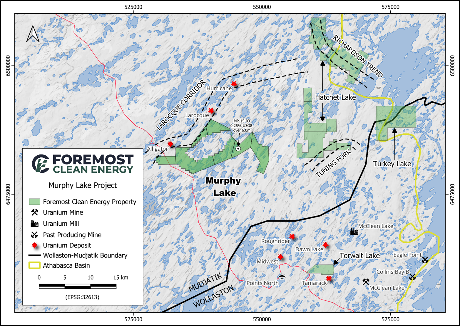
Figure 1. Murphy Lake South Property – Regional Map
2025 Diamond Drill Program Summary
The 2025 drill program was focused on the area surrounding historical hole MP-17-19 (0.03% U₃O₈ over 7.5 metres1) and along strike from MP-15-03 (0.25% U₃O₈ over 6 meters2), MP-16-11 (0.13% U₃O₈ over 12.5 meters3), and MP-16-17 (0.03% U₃O₈ over 22.5 meters4) (Figure 2). These intersections define a 400m mineralized corridor characterized by strong hydrothermal alteration and reactivated graphitic basement structures, features consistent with Athabasca-style uranium systems. Drilling was designed to test along strike and up dip of the historic intersections. Hydrothermal alteration consisting of hematite, clay, and bleaching, with lesser chlorite, was commonly observed both above and below the unconformity. In addition, elevated radioactivity (2-3x background measurements) was encountered in MP25-003 and MP25-007 in graphitic structures below the unconformity and in MP25-006 in the sandstone just above the unconformity. These alteration features and radioactivity anomalies are consistent with those typically associated with uranium-bearing systems elsewhere in the Athabasca Basin. A full description of individual holes can be found below.
__________________________1 Saskatchewan Mineral Assessment File MAW022892 Saskatchewan Mineral Assessment File MAW017243 Saskatchewan Mineral Assessment File MAW022344 Saskatchewan Mineral Assessment File MAW02243
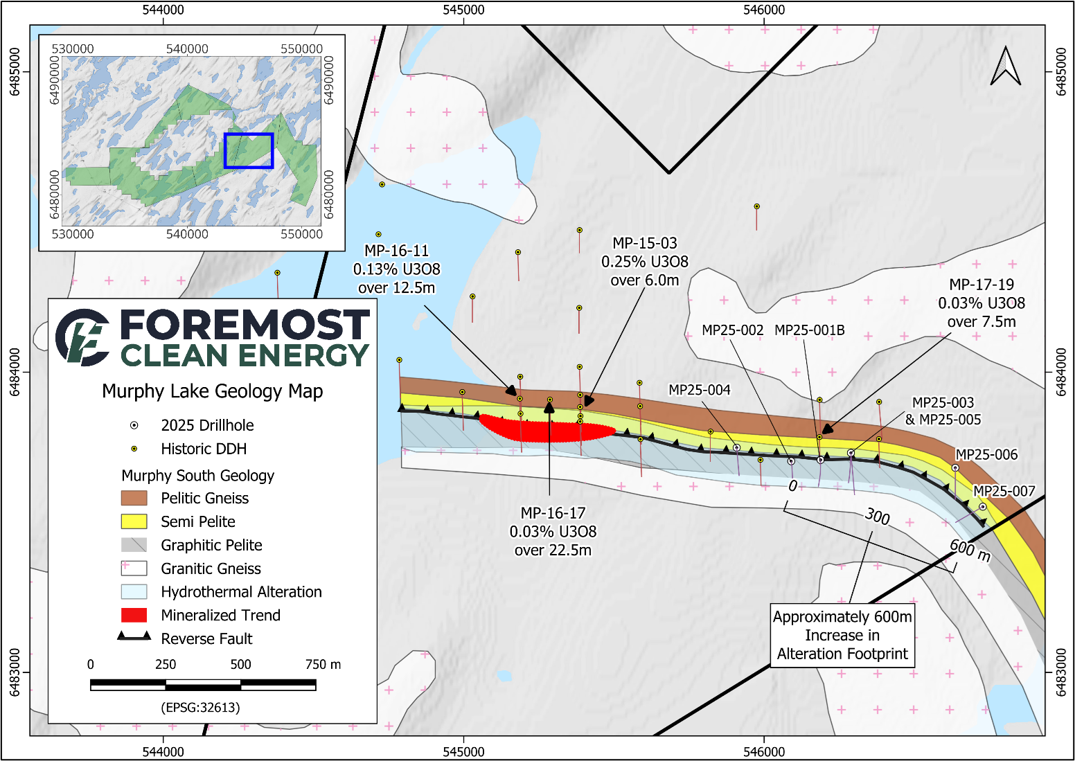
Figure 2. Murphy Lake South Property – 2025 Drilling Compilation Map
Drillhole Descriptions
Drilling successfully intersected the targeted graphitic structural corridor at Murphy, confirming a classic setting for unconformity-style uranium mineralization. Each drill hole collar location is summarized in Table 1 and in description below:
- Hole MP25-001B intersected a 17.5 m fault zone at a depth of 258.5 m within sandstone, characterized by clay and hematite alteration. The unconformity was encountered at 275.4 m. A second, strongly hematite-altered fault zone was intersected over 4.5 m beginning at 289.6 m. The hole was finished in semi-pelitic gneiss at 338.5 m.
- Hole MP25-002 intersected a 2.3 m clay-altered fault gouge at 253.3 m. The unconformity was encountered at 270.6 m within a 9.8 m fault zone exhibiting hematite and clay alteration. The hole was finished in granitic gneiss intercalated with minor granite pegmatite at 344.3m.
- Hole MP25-003 was moderately to strongly bleached from 200.0 m to 240.0 m. From 240.0 m to 300.0 m, strong clay alteration was observed, with moderate clay alteration continuing to 350.0 m. Strong, pervasive hematite alteration occurs over a 2.0 m interval beginning at 258.0 m, just above the unconformity, which was intersected at 267.1 m. A graphitic shear zone was encountered from 273.2 m to 286.0 m, containing elevated radioactivity averaging 208 CPS over 1.0 m beginning at 274.6 m (figure 3). The hole was finished in granitic gneiss at 380.0 m.
- Hole MP25-004 was moderately bleached from the base of the overburden at 22.8 m to 105.0 m. Pervasive fracturing and clay alteration were observed from 263.0 m to the unconformity at 276.6 m, with a 4.0 m interval of strong hematite alteration immediately above the unconformity. The hole was finished in granitic gneiss at 359.6 m.
- Hole MP25-005 intersected two clay-altered fault zones in the sandstone, measuring 3.7 m and 3.5 m, beginning at 47.0 m and 57.0 m, respectively. Strong clay alteration wrapping the unconformity begins at 245.0 m and continues through the contact, which occurs at 269.1 m, extending into the basement to 273.0 m. A graphitic pelite unit with weak chlorite and clay alteration was encountered from 272.9 m to 287.7 m. Below this, moderate to strong clay alteration within granitic gneiss persists to 340.0 m. The hole was finished in granitic gneiss 428.1 m.
- Hole MP25-006 contained several small (
The views and opinions expressed herein are the views and opinions of the author and do not necessarily reflect those of Nasdaq, Inc.