Foremost Clean Energy Receives 3-Year Exploration Permit and Announces Gravity Survey at Turkey Lake Uranium Project, Athabasca Basin, Saskatchewan
Ground-Based Gravity Survey Launching in December to Follow Up on Historic Uranium Intercepts First Defined by Cameco and Denison Mines
VANCOUVER, British Columbia, Dec. 01, 2025 (GLOBE NEWSWIRE) -- Foremost Clean Energy Ltd. (NASDAQ: FMST) (CSE: FAT) (“Foremost” or the “Company"), Foremost Clean Energy Ltd. (NASDAQ: FMST) is pleased to announce that the Saskatchewan Ministry of Environment has issued a three-year exploration permit for the Company’s Turkey Lake Uranium Project (“Turkey Lake”), located on the eastern margin of the Athabasca Basin in northern Saskatchewan (see Figure 1). The permit is valid until December 31, 2028, and authorizes up to 75 drill holes, line cutting, trail use, and related exploration activities.
The Company is also pleased to announce a ground-based gravity survey at Turkey Lake is scheduled to commence in December. The gravity survey will refine targeting ahead of an anticipated 2026 drill program, which will follow up on uranium intercepts that were initially identified through historic work by Denison Mines Corp. (“Denison”, NYSE American: DNN, TSX: DML), and Cameco. The survey will be conducted by MWH Geo Survey (“MWH”), a leading geophysical contractor with more than 40 years of experience throughout the Basin.
Foremost’s President and CEO Jason Barnard, President and CEO commented: “We are very pleased to receive a three-year exploration permit for Turkey Lake, which allows Foremost to advance this underexplored project along the eastern Athabasca Basin margin. Historic work by industry leaders like Cameco and Denison has already confirmed unconformity-associated uranium in multiple holes, including 0.16% U₃O₈ over 0.6 metres in TUR-4 and 0.12% U₃O₈ over 0.5 metres in TL-10-13. This foundation of past success, combined with shallow unconformity depths and a largely untested 10-kilometre conductor system, presents a compelling opportunity. Furthermore, the current industry landscape is creating a perfect environment for uranium exploration, where significant new discoveries are not just valuable, but imperative. The gravity survey will refine our understanding of the structural framework as we prepare for a targeted drill program in 2026, positioning us to capitalize on powerful market tailwinds.”
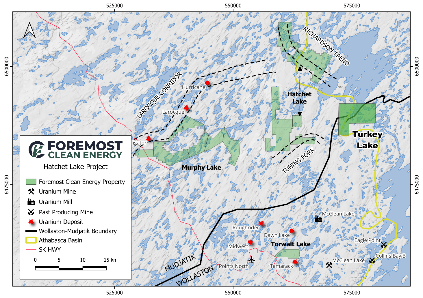
Figure 1: Turkey Lake Regional Context Map
Gravity Survey Details
The program is anticipated to comprise approximately 1,312-station ground gravity survey collected at 100-metre station intervals on 200-metre line spacing across a priority NE-trending conductive corridor extending beyond the Athabasca Basin margin (see figure 2). The survey is designed to identify gravity lows associated with hydrothermal alteration and map fault-controlled fluid pathways.
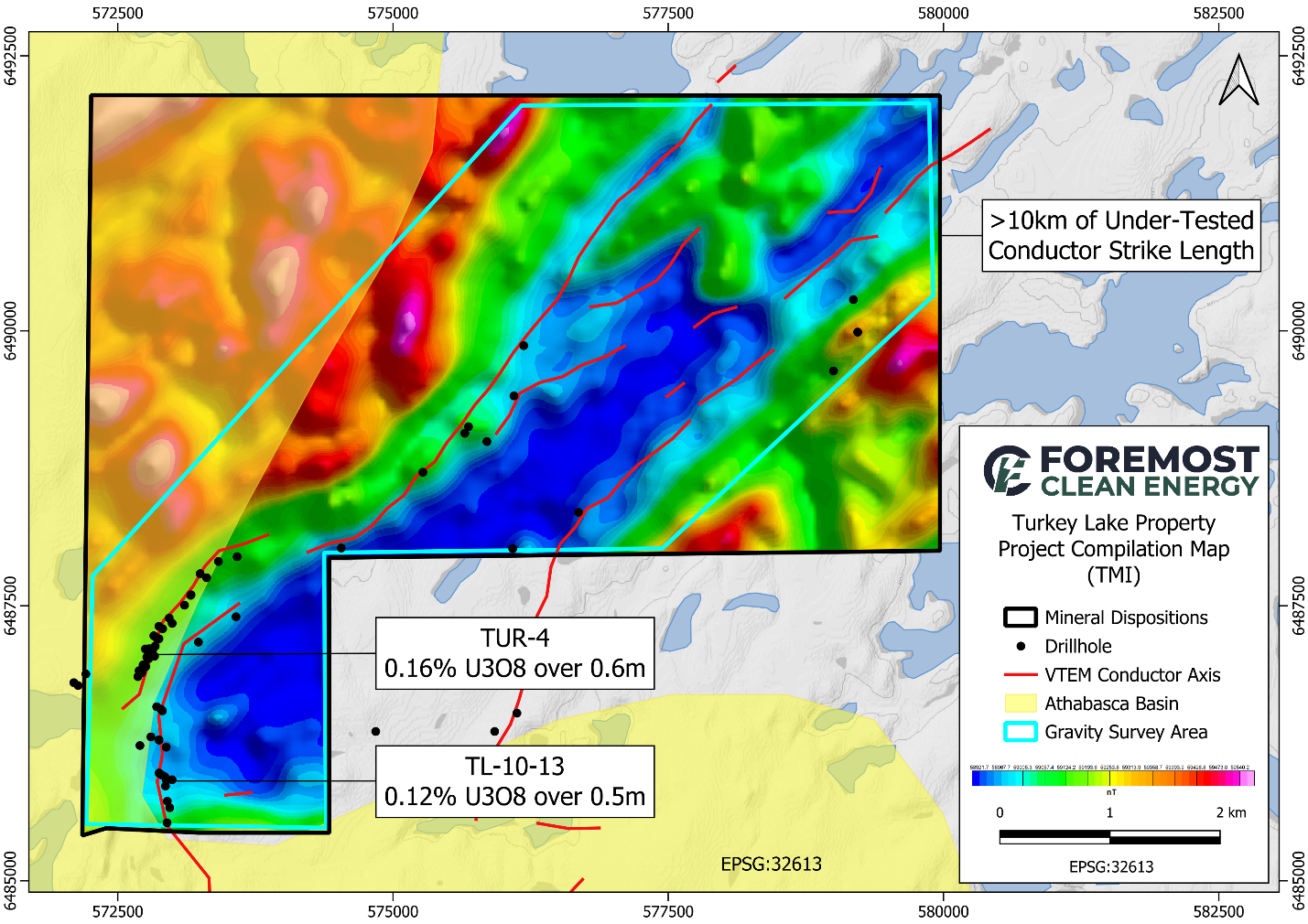
Figure 2: Turkey Lake Compilation Map
Turkey Lake Property Overview
The Turkey Lake Property consists of one mineral claim totaling 9,363 acres (3,789 hectares) situated along the eastern edge of the Athabasca Basin. The project benefits from excellent proximity to key regional infrastructure:
- ~23 km north of the McClean Lake Mill
- ~25 km north of the Eagle Point Mine
Turkey Lake hosts shallow unconformity depths (
The views and opinions expressed herein are the views and opinions of the author and do not necessarily reflect those of Nasdaq, Inc.