Belltopper Mineralisation Modelling Defines Prospectivity
HIGHLIGHTS
- Belltopper Gold Project Exploration Target defined.
- Belltopper is located within the gold prolific Bendigo Tectonic Zone in Victoria and approximately 50 km SSW of the high-grade world-class Fosterville Gold Mine.
- The Exploration Target was defined through geological modelling of priority target reefs following completion of 2024 drilling and the release of assay results.
- The Exploration Target excludes numerous emerging prospective zones and conceptual targets based on progressive geological and geochemical understanding.
- Evolving geology model provides multiple, high priority, drill-ready targets.
- Diverse range of mineralisation styles demonstrated by current work programs.
- Potential for Intrusion Hosted/Intrusion Related mineralisation and Fosterville-style, world-class, high-grade gold to be tested in forward drill programs.
VANCOUVER, British Columbia, Sept. 24, 2024 (GLOBE NEWSWIRE) -- Novo Resources Corp. (Novo or the Company) (ASX: NVO) (TSX: NVO) (OTCQX: NSRPF) is pleased to provide an update regarding the Company’s highly prospective Belltopper Gold Project (“Belltopper”) in the Bendigo Tectonic Zone, Victoria (Figure 1). Integrating results from the current 2024 exploration program, the Company have an updated 3D model of priority target reefs at Belltopper, which has resulted in the definition of an Exploration Target.
An Exploration Target is now presented for the Belltopper area based on seven reefs considered to show high prospectivity based on geological, drilling, and historical data (Table 1).
Table 1. Exploration Target for the Belltopper Project, Victoria. Figures may not compute due to rounding.
| Metric | Low case (approximation) | High case (approximation) |
| Tonnage range | 1.5 Mt | 2.1 Mt |
| Grade range | 6.6 g/t Au | 8.4 g/t Au |
| Contained Au range | 320 koz Au | 570 koz Au |
Clarification statement: An Exploration Target as defined in the JORC Code (2012) is a statement or estimate of the exploration potential of a mineral deposit in a defined geological setting where the statement or estimate, quoted as a range of tonnes and a range of grade (or quality), relates to mineralisation for which there has been insufficient exploration to estimate a Mineral Resource. Accordingly, these figures are not Mineral Resource or Ore Reserve estimates as defined in the JORC Code (2012). The potential quantities and grades referred to above are conceptual in nature and there has been insufficient exploration to estimate a Mineral Resource and it is uncertain if further exploration will result in the estimation of a Mineral Resource. These figures are based on the interpreted continuity of mineralisation and projection into unexplored ground often around historical workings. The Exploration Target has been prepared in accordance with the JORC Code (2012).
Novo Executive Co-Chairman and Acting CEO Mike Spreadborough said:
“Our Belltopper Project is an exciting, high-grade gold opportunity located in a tier-one gold region. The Novo geological team has done an outstanding job to define the geology, mineralisation and prospectivity of Belltopper supported by a successful period of work delivered at the Project, including the six-hole, 2,529 m, diamond drill program completed in Q2 this year. Belltopper is an exciting opportunity and has the potential to grow in size and scale and the focus will now turn to expanding the prospectivity of the project.”
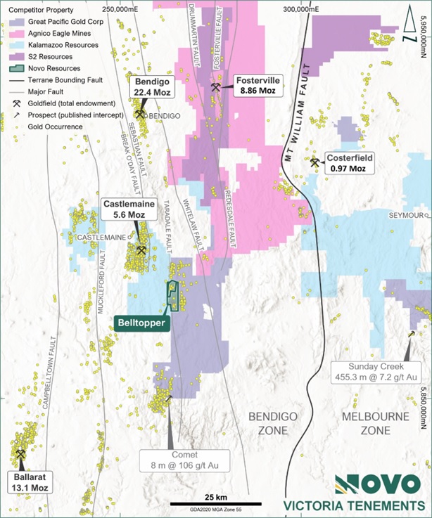
Figure 1. Belltopper Gold Project location map with regional gold occurrences and major structures1.
The mineralisation presented in the body of this announcement is not necessarily representative of mineralisation throughout the Belltopper Gold Project. Intercepts are expressed as down-hole intersections and should not be presumed to represent true widths, which vary from hole to hole and between reefs (refer JORC Table 1). In addition, all references in this announcement to tonnage, grade, contained Au and associated ranges are expressed as approximations.
Certain results at Belltopper were obtained (and reported in accordance with Canadian continuous disclosure requirements) prior to the Company’s listing on ASX in September 2023 and are now reported to ASX in accordance with the JORC Code 2012 for the first time.
Belltopper is located 120 km northwest of Melbourne and approximately 50 km south of Agnico Eagle’s Fosterville Gold Mine (Figure 1) in the Bendigo Zone, an area with historical gold production of more than 60 million ounces.
Novo recently completed a six-hole, 2,529 m, diamond drill program in Q2 2024 (see the Company’s ASX announcement dated 4 June 2024 released to ASX on 5 June 2024), commensurate with a re-logging and infill assay program on key historic holes. Recent campaigns build on previous drilling (2021 – 2022) and deliver new significant gold intercepts across a range of structural targets, including the discovery of two new gold reefs with significant strike potential.
The Company is focussed on developing a program that aims to grow the Exploration Target, whilst systematically testing an evolving pipeline of high priority, drill ready, conceptual shallow and deeper targets, including: Fosterville-style (epizonal), anticline related targets; Bendigo-style saddle-reef targets; Costerfield-style faults; and intrusive-igneous targets such as the gold-bearing Missing Link Granite, on theme with high-value Victorian examples of intrusion hosted deposits such as A1 and Morning Star in the Walhalla – Woods Point gold province, and developing projects such as Southern Cross Gold’s, Sunday Creek, 60 km north of Melbourne.
BELLTOPPER EXPLORATION TARGET DEFINITION DETAIL
A characteristic feature at Belltopper is the dense network of apparent high-grade gold ± antimony reefs that cluster in the northwest quadrant of the project adjacent to the regional Taradale Fault. An Exploration Target (Table 2) is presented for the Belltopper Project area based on seven individual reefs (Figure 2) considered to show high prospectivity based on geological, drilling and/or historical data outlined in Tables 3 and 4.
Table 2. Exploration Target for the Belltopper Project, Victoria. Figures may not compute due to rounding.
| Metric | Low case(approximation) | High case(approximation) |
| Tonnage range | 1.5 Mt | 2.1 Mt |
| Grade range | 6.6 g/t Au | 8.4 g/t Au |
| Contained Au range | 320 koz Au | 570 koz Au |
Clarification statement: An Exploration Target as defined in the JORC Code (2012) is a statement or estimate of the exploration potential of a mineral deposit in a defined geological setting where the statement or estimate, quoted as a range of tonnes and a range of grade (or quality), relates to mineralisation for which there has been insufficient exploration to estimate a Mineral Resource. Accordingly, these figures are not Mineral Resource or Ore Reserve estimates as defined in the JORC Code (2012). The potential quantities and grades referred to above are conceptual in nature and there has been insufficient exploration to estimate a Mineral Resource and it is uncertain if further exploration will result in the estimation of a Mineral Resource. These figures are based on the interpreted continuity of mineralisation and projection into unexplored ground often around historical workings. The Exploration Target has been prepared in accordance with the JORC Code (2012).
Table 3. Significant reefs with summary of key inputs to the Exploration Target.
| Target Reefs^ | Reef No. on Figure 2 | Historic underground development | Historical production data | Drilling | Mapped | Surface sampling |
| Leven Star | 1 | Minor | - | Significant | Yes | Yes |
| Missing Link | 2 | Yes | Yes | Yes | Yes | Yes |
| Never Despair | 3 | Yes | Yes | Yes | Yes | Yes |
| O’Connor’s | 4 | Yes | Yes | Yes | Yes | Yes |
| Queens / Egyptian | 5 | Yes | Yes | Yes | No | No |
| Hanover Reef Fault | 6 | Yes | Yes | Yes | Yes | Yes |
| Piezzi Reef / Stackyards | 7 | Yes | Yes | Yes | Yes | Yes |
^Selection criteria for the sub-set of seven reefs from the wider network of reefs at Belltopper considers both target confidence and target ounce potential, with the latter nominally set at >20,000 oz Au to be considered for inclusion into the Exploration Target.
Figure 2 depicts significant intercepts returned across all phases of drilling. Callouts are provided for all >50 m.g/t Au2 intercepts, and select intercepts from important target reefs, as well as the gold-bearing Missing Link Granite, a porphyritic felsic intrusion with IRGS (Intrusion Related Gold System) characteristics that outcrops centrally to the network of high-grade reefs at Belltopper. This Figure highlights the exceptional prospectivity and diverse nature of mineralisation present at Belltopper.
Reefs belonging to the Exploration Target are typically narrow, discrete, continuous structures that can be traced up to 1.5 km in strike and predominantly fall into two geometrical sets: a more common moderate to steep NE dipping set; and a less common subvertical to steep NW dipping set. Both sets are oblique to north-south trending stratigraphy and crosscut both stratigraphy and the regional upright folds. The reefs commonly manifest as narrow (2 m.g/t Au4 intercepts with corresponding drill collar details and location map please refer to Appendices 1, 2 and 3.
Table 4. Geological inputs for each reef to the Exploration Target. All reefs are identified on Figure 2.
| Reef | Dip / dip direction | Strike continuity (m) | Dip continuity (m) | Potential mining width (m) | Mean vein width | Characteristics of mineralisation |
| Leven Star | 85° to SE | 800 | 370 | 2.6 | 2.60 | Sulphide rich tectonic breccia +- disseminated and stringer hosted sulphides. Occasional zones of white quartz veining stockwork (Au + As, Sb +- Bi, Sn, W) |
| Missing Link | 75° to ENE | 920 | 250 | 1.5 | 0.15 | Tectonic breccia +- disseminated sulphides (Au + As) |
| Never Despair | 80° to ENE | 670 | 250 | 1.5 | 0.20 | Puggy tectonic breccia (Au + As) |
| O’Connor’s | 70° to ENE | 1,500 | 300 | 1.5 | 0.33 | Tectonic breccia +- disseminated sulphides (Au + As) |
| Queens/Egyptian | 78° to ENE | 780 | 350 | 1.5 | 0.20 | Tectonic breccia +- disseminated sulphides and irregular white quartz veinlets (Au + As) |
| Hanover Reef | 70° to NE | 650 | 250 | 1.5 | 0.25 | Broad zone of quartz stockwork veining surrounding narrow sulphide rich tectonic breccia (Au + As) |
| Piezzi Reef / Stackyards | 75° to ENE | 1,450 | 250 | 1.5 | 0.20 | Narrow tectonic breccia overprinting bucky white quartz vein surrounded by irregular quartz veining (Au + As, Bi) |
The wide array of orientations for mineralised reefs (i.e. mineralised structures) at Belltopper is an important feature that has resulted in localised zones of structural and mineralisation overprint. Several of these overprinting zones have been modelled and are captured in the evolving pipeline of high-priority targets; including structural overprints along segments of the Exploration Target reefs that represent potential zones of enhanced gold mineralisation and opportunities to grow the Exploration Target (Figure 2).
Table 2 and Table 5 outline the Exploration Target, and the significant reefs included within the current Exploration Target at Belltopper.
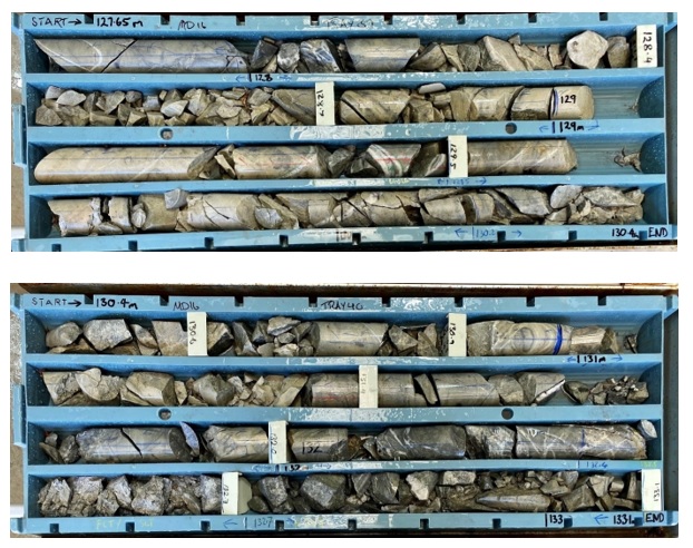
Figure 3. MD16 (127.65 m – 133.1 m). Leven Star Reef intersection in fresh sulphide material (14.0 m @ 6.15 g/t Au from 120 m, including 7.60 m @ 6.66 g/t Au from 121.9 m and 3.0 m @ 11.06 g/t Au from 131 m)5. Peak gold assay is associated with a discrete sulphide rich fault breccia and increased quartz stock-work veining. Intercepts are expressed as down-hole intersections and should not be presumed to represent true widths, which vary from hole to hole and between reefs (refer JORC Table 1).
Table 5. Significant reefs with breakdown of gold targets included within current Exploration Target at Belltopper. Figures may not compute due to rounding.
| Expressed as approximations | |||||||
| Target Reefs | Reef No. on Figure 2 | Low Case Tonnage (t) | High Case Tonnage (t) | Low case Grade Range (g/t Au) | High Grade Range (g/t Au) | Low Case Ounces (Oz Au) | High Case Ounces (Oz Au) |
| Leven Star | 1 | 420,000 | 590,000 | 4.6 | 5.1 | 60,000 | 100,000 |
| Missing Link | 2 | 150,000 | 220,000 | 7.5 | 9.8 | 40,000 | 70,000 |
| Never Despair | 3 | 110,000 | 160,000 | 7.5 | 9.8 | 30,000 | 50,000 |
| O’Connor’s | 4 | 290,000 | 430,000 | 7.5 | 9.8 | 70,000 | 130,000 |
| Queens / Egyptian | 5 | 140,000 | 200,000 | 7.5 | 9.8 | 30,000 | 60,000 |
| Hanover Reef Fault | 6 | 120,000 | 170,000 | 7.5 | 9.8 | 30,000 | 50,000 |
| Piezzi Reef /Stackyards | 7 | 240,000 | 360,000 | 7.5 | 9.8 | 60,000 | 110,000 |
| TOTAL | - | 1,500,000 | 2,100,000 | 6.6 | 8.4 | 320,000 | 570,000 |
Clarification statement: An Exploration Target as defined in the JORC Code (2012) is a statement or estimate of the exploration potential of a mineral deposit in a defined geological setting where the statement or estimate, quoted as a range of tonnes and a range of grade (or quality), relates to mineralisation for which there has been insufficient exploration to estimate a Mineral Resource. Accordingly, these figures are not Mineral Resource or Ore Reserve estimates as defined in the JORC Code (2012). The potential quantities and grades referred to above are conceptual in nature and there has been insufficient exploration to estimate a Mineral Resource and it is uncertain if further exploration will result in the estimation of a Mineral Resource. These figures are based on the interpreted continuity of mineralisation and projection into unexplored ground often around historical workings. The Exploration Target has been prepared in accordance with the JORC Code (2012).
BASIS FOR THE BELLTOPPER EXPLORATION TARGET
Novo applied its geological understanding of the reef network at Belltopper, drawing upon 3D reconstruction of historic mining (Figure 4) and exploration data, drilling data, structural and geochemical data, field mapping (including high-resolution LiDAR™ interpretation), and surface rock chip sampling. Tables 3 and 4 summarise key inputs into each reef.
Mineralisation volumes were defined from strike and dip continuity and potential modern “mineable width”. Continuity extents and width were based on geological interpretation and modelling by Novo (see Table 4 and Figure 2).
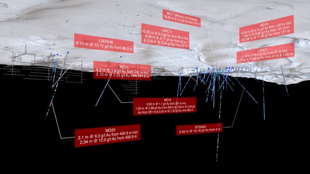
Figure 4. Example from Novo's 3D Model, showing historical mine infrastructure, diamond drilling and assay callouts, beneath LiDAR™
The Leven Star Reef (#1) was based on a 3D wireframe from drilling6. The volumes were modified by three factors: (1) geological continuity factor, (2) payability factor; and (3) mine factor.
The geological continuity factor allows for potential breaks in local geological continuity related to faulting or reef pinch-out. Values (all of which are approximations) averaged 0.85 for the High case and 0.75 for the Low case. A value of 1.0 was applied to the Leven Star Reef based on drilling information.
The payability factor acts to report potential “mineable tonnages” at a cut-off grade within the target zone, which averaged (approximately) 0.33 for the High case and 0.25 for the Low case. The payability for the Leven Star Reef was based on the percentage of estimation6 blocks reported at a nominal underground mining cut-off of 2.7 g/t Au – which was approximately 0.25.
The mine factor accounts of any mining that has been undertaken within the target zone. Values applied range from approximately 0.5 for the Queens/Egyptian Reef (#5 in Figure 2) to 0.98 for the Leven Star Reef (#1 in Figure 2).
The Exploration Target is located within both oxide and fresh mineralisation. A weighted bulk density of approximately 2.65 t/m3 was applied to both the High and Low cases to define mineralisation tonnages based on drilling information from the Leven Star Reef. No other bulk density data is available, and it is assumed that the Leven Star data represents other reefs.
The High and Low case Target Mineralisation Tonnages have been calculated using the following (Equation 1):
Strike continuity x dip continuity x mineable width x geological continuity x payability x mine factor x bulk density
Where the underlined, factors are different between the Low and High cases. The other factors were not changed as the CP/QPs considered that the geological continuity and grade payability factors provided enough variation in the context of a conceptual model – the Exploration Target.
Grade was assigned dominantly from historical data. For the Leven Star Reef, the Low grade was assigned from the block model6, and for the High case via a 10% upgrade. For the other reefs a base historical grade of 1 oz/t Au (31 g/t Au) was used. This grade was based on historical research which indicates recovered grades of 1-2 oz/t Au (31-62 g/t Au)5. A conservative value of 31 g/t Au was applied. This grade is likely to reflect selective mining from narrow 2-3 foot (0.6-0.9 m) wide stopes and a degree of hand sorting. The reefs were very narrow, averaging about 0.2 m width, varying from 0.1 m to 1 m. Most reefs rarely exceeded 0.6 m, with the mean variation between 0.15 m to 0. 3 m.
The historical reports for the Belltopper area provide no stope widths. Drive backs (roof) in sub-vertical to vertical reefs in Central Victoria were typically c. 3-4 feet wide (0.9-1.2 m), other than for very wide reefs and stockwork zones (e.g. some in Ballarat, Bendigo, Castlemaine, etc.). Based on underground observation of Central and Eastern Victorian narrow (
The views and opinions expressed herein are the views and opinions of the author and do not necessarily reflect those of Nasdaq, Inc.